تعريف الخريطة التفاعلية
تهدف الخريطة التعليمية لعرض بيانات الحالة التعليمية في مصر بطريقة تفاعلية، لأن عملية تطوير التعليم يجب أن تشمل جميع الأطراف المعنيين بالعملية التعليمية. تقدم الخريطة معلومات مختلفة، خصوصًا البيانات الحكومية، في خريطة جغرافية تفاعلية، وتسمح للمستخدمين بإدخال آرائهم عن حالة وتجهيزات المدارس. تساعد الخريطة في تقديم مشكلات التعليم بطريقة واضحة، وتعرض المعلومات على مستويات المديريات أو المدارس بمختلف المحافظات.
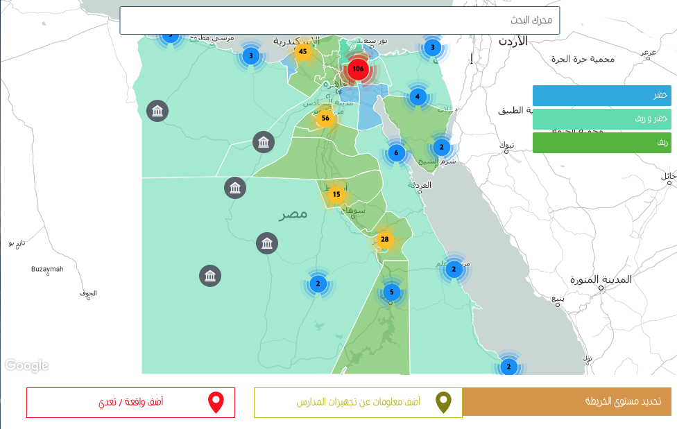
تنقسم الخريطة إلى ثلاثة مستويات؛ يعرض الأول بيانات الإدارات التعليمية، ويقدم الثاني معلومات عن تجهيزات المدارس، فيما يختص الثالث بعرض المعلومات عن وقائع العنف المدرسي. وتقسم الخريطة المحافظات بناءً على طبيعتها الحضرية أو الريفية أو المختلطة، مستخدمة ألوان الأزرق والأخضر والفيروزي لكل منهم تباعًا.
يشمل المستوى الأول نوعين من المعلومات؛ أولهما البيانات الخاصة بكل محافظة، كأعداد الإدارات والمدارس العامة والخاصة وأعداد الطلاب والمدرسين، والثاني هو المؤشرات التعليمية لكثافة الفصول ونسبة المدرسين للطلاب. يعتمد هذا المستوى على مصادر حكومية، هي الكتب الإحصائية لوزارة التربية والتعليم، والتي تقدم بيانات المراحل التعليمية والتقسيم الريفي والحضري لكل محافظة، لكنها لا تشمل بيانات على مستوى الإدارات أو المدارس.
ويعرض المستوى الثاني للخريطة تجهيزات المدارس، ويعتمد على الجمهور لتسجيل أي نقص في التجهيزات عن طريق ملء الاستمارة الخاصة على صفحة الخريطة، والتي تشمل تفاصيل مثل اسم المدرسة والمرحلة التعليمية والإدارة والمحافظة. يختار المستخدم في بند «المدرسة غير مجهزة من حيث» أي اختيار من بين الكهرباء أو الصيانة أو التابلت أو الكثافات العالية أو المعلمين غير المدربين.
أما المستوى الثالث والأخير فيعرض وقائع العنف المدرسي، وينقسم إلى نوعين حسب مصدر المعلومات؛ الأول هو المعلومات عن حالات العنف المدرسي كل سنة دراسية والتي جمعها الفريق من الصحف اليومية والمواقع الإخبارية المختلفة، أما الثاني فيعتمد على تفاعل مستخدمي الخريطة وتسجيلهم لوقائع العنف المدرسي التي شهدوها في استمارة خاصة على صفحة الخريطة. بعد تلقي أي معلومة من الجمهور، في المستويين الثاني أو الثالث، يراجع فريق عمل الخريطة البيانات ويتأكد من صحتها إما عن طريق الصحف أو الشركاء المختلفين، وعند تأكيد المعلومة تظهر على الخريطة.